
Day Trips from Paris
The Hiking Trail in Versailles
This time, Monsieur et Madame Easy Hiker continue their exploration of the hiking trails near Paris, this time in the Forest of Versailles.
One of the most attractive features that a hiking landscape can have is a lake. Think about it: when did you last encounter a lake without immediately putting it down as one of the highlights of your hike?
No picturesque scene can be so picturesque that it would not be enhanced by a body of water in its middle, and even in the dullest and most bog standard forest, the sight of a lake will immediately make you reach out for your camera. Do you agree?
Then today’s walk should be right up your hiking trail, because it features not one but three lakes, all of them lovely and following each other in close succession like pearls on a string.

Something else I would want to mention about the Forest of Versailles: the trail feels more like a hike than most of the other walks in the greater Parisian area that we have done. Many of these walks lead you – at least for some of the way – through suburban streets, often with the Peripherique (the motorway ring road) in earshot. There is very little of that in the Forest of Versailles.
Once you are inside, little reminds you of the fact that you are in one of the most densely populated areas in Europe, and since the French are not particularly keen on longwalking tours (anything longer than the hike to the nearest bar bistro, to be precise), you will have the forest mainly to yourselves.
In theory at least. Unless you have, like us, chosen to explore the hiking trail in Versailles Forest on the day of the so-called EcoTrail and consequently have to share it with 3000 endurance runners from all over France.

The Forest of Versailles lies, as you may have guessed, in close vicinity to the famous Chateau, and since you can do the walk in less than the four hours it took us (we must have been the slowest living beings in the forest on that day – except for the slugs, possibly), you can also combine it with a brief trip to the Versailles’s main tourist attraction. There will not be enough time to explore the castle in great depth, perhaps, but if you leave Paris early in the morning, you can have a good look at the main rooms and even the surrounding parklands before setting out on the trail.
In that case, you will want to go to the RER station Versailles Rive Gauche (RER C from Champ de Mars, i.e. the station just underneath the Eiffel Tower), from where you can walk to the castle in about three minutes.
After your visit, take a 10 minute walk to our Paris easy hiking “trailhead” which is located at the other local train station, called Versailles Chantiers.
If, however, you want to go directly on the hike, you should take either the Transilien train from Montparnasse (direction Rambouillet and Chartres) or the Transilien train from La Defense (direction La Verrière) and get off at Versaille Chantiers.
Do NOT take the RER line C train to Versailles Chantiers unless you want to be ferried through the Parisian suburbs on a 2-hour journey. (That’s what we mistakenly did. Not only were we the slowest living beings in the forest that day: we were also the ones who had taken the most convoluted route of getting there.)
Also, do NOT buy a return ticket, because on the way back, we will use a different station which lies in a different zone.
From the station Versaille Chantiers, turn slightly to the right (about “one o’clock” for those among you who know what I am talking about). The street you will reach is called Rue des Etats Generaux.
Turn left here and take the first street on your left, called Rue des Noailles. (This is a busy urban area with cafes, restaurants and, more to the point, a bakery and a supermarket, so you can buy everything you could possible need for your walk right here. There is no need to stock up on anything before you leave Paris.)
Continue down this street past the Avenue de Sceaux on your right (you can glimpse the castle at the bottom of that street) into Rue Edouard Charton.

Follow this street for another 200 meters across the railway bridge. At the end of the parking lot which you can see on your left hand side there is a stairway that leads you up into the forest. From here onwards, it’s easy: just follow the “balisages” trail markers, in this case a white and a red stripe which looks much like a Polish flag.

When describing other walks, I have said quite a few things about the French system of marking trails, not all of them flattering. But for this walk, the white-red balisages work perfectly.

The “flags” are applied frequently, often as “reassurance markers” after you were asked to perform a turn (particularly on the first part of the trail), and there are even crosses on dead ends to indicate mistakes which tell you to trace your way back to where you should have taken a different turn. All of this makes sure that only an absolute idiot can lose his way here! (We managed it twice, all the same.)
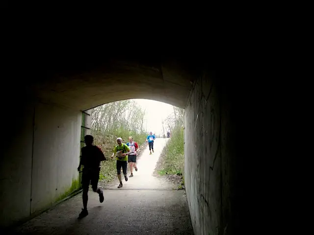
After about 15 minutes, you enter a tunnel underneath a busy road. Take the footpath on your right immediately behind the tunnel. Cross the road at the end of the path and turn right into the forest.

After another 30 to 45 minutes, you will encounter the first lake, the Etang de la Geneste, on your left hand side. A couple of benches by the banks invite you to take a rest. This would be a nice time to unwrap what you have bought at the bakery, if you have been able to resist so far.

Next up is the Etang du Val on your right hand side, more or less immediately followed by the Etang du Moulin à Renard, the largest lake of the three.

Note that, as soon as this lake comes into sight, you should make a right turn followed by a left turn so you continue your walk with the lake on your left hand side.
Behind the lake, there is a sharp turn on your left. Continue until you reach the motorway and follow the path to the bridge. Behind the bridge, we leave the white-red trail and turn right into the little town ahead of us which is called St Cyr. Just continue straight ahead, and after about 5 to 10 minutes, you will reach St Cyr station.
There are frequent trains from here to Montparnasse station in central Paris. Please note, however, that this station is already in Zone 5, so you cannot use the same type of ticket you used to travel to Versailles Chantiers (Zone 4).
And for those who are not yet tired and have some energy left: you can, if you feel like it, walk all the way back from here to Versailles Chantiers station. To do this, turn right after the motorway bridge, about half way to the St Cyr station.
Do NOT follow the red-white balisages: they will take you somewhere else) and follow the yellow balisages from now on.
The trail runs more or less parallel to the railway tracks, which should be on your left hand side, all the way – about 2 or 3 miles – back to Versailles.
For Madame Easy Hiker and myself, however, that would have been too much of a good thing. Mark that down to the fact that we have probably spent too much time in France already. The only hike we could face at this stage was one that had a hot latte at the end of it – somewhere at the nearest bar bistro.
Now that you have discovered this hiking trail in Versailles, why not do it this week-end?


Thanks for all your tips, Beth. We’ve not been back there since, and obviously things like maintenance or redevelopment work could “derail” this work. Glad you liked the walk anyway!
My husband and I took the trail this week, and were unable to cross the pedestrian bridge as detailed at the beginning if the walk due to some redevelopment going on in the surrounding area. However, if you walk further up Rue Edouard Charton, there is a road bridge that goes across the track, and takes you further on up into the woods, where you can easily readjust your route.
We sadly only discovered that it was possible to cross the track on our return from the walk, so I thought I pass it on to anyone intending to undertake this walk.
The woods themselves were beautifully maintained, and the signage was fairly clear.
Hi, anyone in Versailles reading this want to do this regularly with me and my dog?
C.
Wends, I sincerely hope you do get to visit France and see the many interesting places outside Paris.
I love this one and the forest really captivates me. I wished I can walk to reflect here :) Crossing my fingers for my historic trip to France :)
Thanks for the tip, Felix, and for dropping by. Hope you enjoyed the hike, what with the heat.
Hey all,
I just did this hike and I wanted to give everybody a tip. The RER C actually goes in 2 directions to the stop “Versailles Chantier”. If you take a train that has the end point of “versailles chantier”, it takes you all the way around the suburbs as was described in this post. If, however, you get on a train going towards “saint-quentin-en-yvelines”, the third to last stop is “versailles chantier”. Total trip time from “Champ de mars” to “versailles chantiers” was less than 30 minutes.
Karen, thanks for your visit and comment. I hope more people would be encouraged to do as you do on their next holiday.
I have never been to this part of Europe but have heard many good things about touring France. Hiking was never part of it.
I make it a point to do the eco-type of tours and hiking (beyond the usual attractions) when I travel to a foreign country as I enjoy nature and the great outdoors tremendously. As for lakes and water, we are always attracted to them, they are even more beautiful at sunrise and sunset when the sun reflects in them.
Thanks for the insights!
Thanks for dropping by Debbie. It’s really not known to many that Paris has offerings to the outdoor lovers. I hope, with my blog posts, many more are aware of the possibilities.
I am always amazed at how much there is to do so very near to Paris! Once you leave the city you are very quickly transported to a much quieter side of France. This hike sounds grand and something I would very much enjoy. Love lakes too! They are so peaceful.
Agree about the effects of a body of water on the spirit, Ted. It would be great to be living near a lake or a river… as long as the risk of flooding is controlled.
I agree about the beginning paragraph and the notation about lakes. There is something about a body of water that soothes the human spirit. A hike that has a lake, river, or even a creek is enhanced mightily by that geographic feature.
We were also very pleasantly surprised to see that this trail looked and felt very much like some hikes we did in Germany. And yes, US nature presents itself differently as they do in Europe. In the US, it could really be awesome, in the truest meaning of the word, like what we saw in Utah and the Grand Canyon.
Thanks Cathy. Next time you are in Paris, take the time to do this hike. You’ll love it.
You’ve got a point about lakes — they often are an important part of a great hiking trail or park. The Forest of Versailles sounds very nice. I enjoy following following along on your hikes via these blog posts. Nice photos!
I just think it’s so interesting how different the forest looks from what we’re used to here in California. It’s gorgeous!