Hiking in Germany
Oktoberfest and Easy Hiking
Altmuehltal-Panoramaweg
Trail
200 km in 10 stages from Gunzenhausen to Kelheim, an east-west stretch between Nuremberg and Munich (home of the Oktoberfest) in Bavaria, the southeastern corner of Germany.
The western half of the hiking trail (the five stages west of Eichstätt) is easily accessible by train. The service operates hourly and allows you to commute freely between various towns along the trail.
East of Eichstätt, however, the rails veer off, and the last five stages take you through a less densely populated area.
Profile
Bavaria is, in many ways, a little different from the rest of Germany. Think of it as the rural cousin who, having been patronized by the rest of the family all his life, has suddenly become more prosperous than the lot of them – and not by imitating their ways but by stubbornly insisting on having been right all of the time. Actually, most Germans find Bavarians – with their earthy accents and quaint dress codes – quite loveable.

Bavarians, conversely, have nothing but cold contempt for the rest of the tribe, if they see it like that at all, and even reserve a special term of abuse for them, calling them “Prussians”.
“Prussians”, in the Bavarian worldview, are straight-laced, sober and systematic. They have no sense for beauty and the good things in life, the rhythm of nature and their own absurdity – and, it goes without saying, for humour in general. Actually, their description fits pretty much with what most other Europeans would instantly recognize as “German”.
Bavarians, on the other hand, pride themselves in being anything but strait-laced and positively revel in the contradictions of their national character. They are, for example, politically conservative, but with a healthy contempt for authority of any kind. Some of their politicians are of the distinctly full-flavoured variety – illegitimate children and time spent in foreign police jails for soliciting have, in the past, been no bars to high office.

The Altmühltal-Panoramaweg, a scenic German hiking trail, stretches somewhere between Upper Bavaria and Lower Bavaria, another important frontier, albeit one which is not always and everywhere clearly defined. Are you still with me?
I don’t want to get too deeply into this, but Upper Bavarians are said to be more upfront and “aggressively” Bavarian while Lower Bavarians tend to be a little more low key and, on the whole, grumpier.
The area we visited straddles this frontier and is, if I understand this right, administratively a part of Upper Bavaria, but culturally leaning more towards the Lower end of the Bavarian spectrum.
Speaking about frontiers: the Altmühl is a tributary of the Danube which means that any rain which falls here will wind up in the Mediterranean rather than in the North Sea. The area (as indeed much of Bavaria) therefore lies south of the Continental Divide – largely contiguous with the frontier between the Catholic and the Protestant, the Latin and the Germanic halves of Europe. Maybe that helps to explain a few things.
What we did
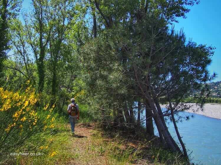
A two-day hike covering stages 4 and 5 of the trail from Solnhofen to Dollnstein and then further to Eichstätt, together a very manageable 32 km.
The hotel in Solnhofen I had wanted to book for our first night was full, so we stayed in Ingolstadt, leaving the last stretch of our journey to the trail itself – still a 40 minute train ride – for the next morning.
That turned out to a blessing in disguise because Ingolstadt – famous mainly as the home of the Audi car factory – is actually rather pretty and well worth a visit.
Note, however, that the town’s train station is a long way away from the city centre, a good 30 minute walk along a charmless and busy ring road, so it’s a good idea to take the bus.
What we liked
If you, like us, have travelled a long way (the better part of one day) to get to the hiking trail in the first place, it’s always nice to be reminded why you bothered to search out this particular trail rather than taking the one you have in front of your own door.
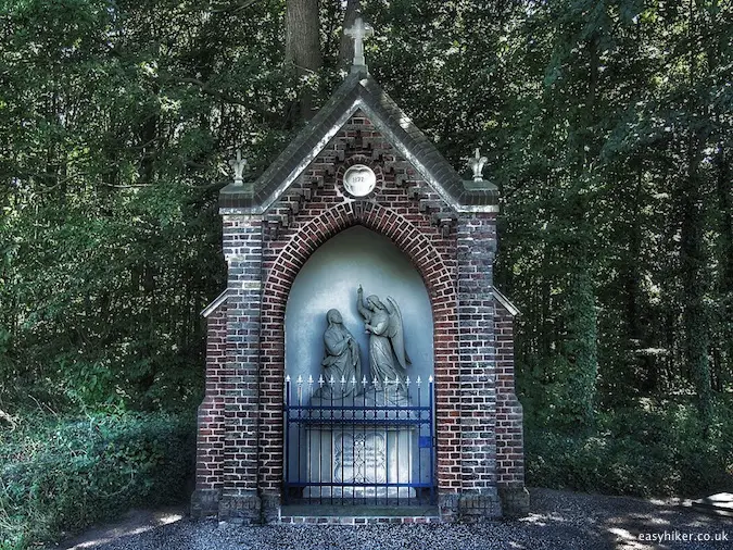
Thankfully, the Altmühltal-Panoramaweg has its ways of doing just that, mainly through the frequent appearance of the Bildstöcke, wayside shrines that have been erected by the locals, some of them hundreds of years ago, often colorfully painted and featuring either small statues of saints or carved crosses.

The great thing about these shrines is that most of them appear to have been built for no apparent reason at all: not in memory of an accident or some other form of gruesome village tragedy, not to ask or to thank God for something special.
They are, rather, as casual and incidental as buildings can be, quick prayers carved into stone or wood merely to appreciate the wonder of being there.
What we liked less
The Twelve Apostles rock formation, the key landmark of the trail and a ubiquitous motive in all the brochures, is a good deal less impressive than those brochures would lead you to believe, and at its foot, about 10 meters below the trail, runs a busy highway, something the tourism literature takes great pains to hide.
I generally do not share the view that hiking adventures are necessarily ruined by any sign of civilization. There are also moments, however, when you want to keep civilization at arm’s length, particularly when it is as its most intrusive.

Overall, our own hiking adventure along the Altmühltal-Panoramaweg perhaps suffered a little from a poor choice of stages. If I were to come back, I would concentrate on the eastern half of the hiking trail, probably starting in Kelheim with what looks like the most picturesque stage of the trail (stage 10).
Towns to explore
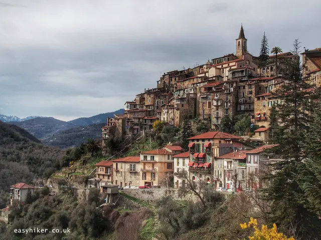
Eichstätt, the town at the end of stage 5, is a real gem, and wherever you hike along the Altmühltal-Panoramaweg, you simply MUST take the time to pay a visit. It is full of beautiful baroque buildings – Baroque residences and Rococo churches are the twin glories of Bavarian architecture – and just remote enough to keep away the large tourist hordes.
What’s more, the large number of students (Eichstätt, pop. 15,000, is the smallest city in Europe to accommodate a University) ensures that the place does not feel as geriatric as some other German tourist towns.

The Wider Scene
Regensburg, one of most ancient and attractive towns in Germany, is only a 20 minute train ride away from Kelheim, so make sure you pay a visit if you hike on the eastern half of the Altmühltal-Panoramaweg.
And, of course, once you are in Bavaria, you may also want to explore the Hofbräuhaus, the Oktoberfest and the Alps. You will have to go to Munich for that (train journeys from the area will take you roughly two hours), but please note that, while the Alps and the Hofbräuhaus are always there, the Oktoberfest only covers the last two weeks of September.

How to get there
Munich is a major international rail and air traffic hub. Trains from Munich Central Station to Eichstätt run about once every hour. (Take the train to Eichstätt Bahnhof and then, to go to the city centre, a rail shuttle to Eichstätt Stadt or Eichstätt Town.)
If you come from Northern Germany, you are most likely to use Ingolstadt as your point of access. Trains from Ingolstadt to Eichstätt and most other towns on the western half of the trail take between 30 and 50 minutes and leave in hourly intervals.
More Information
From the Germany Tourism website. Brief description and an altitude profile.
From the German news magazine DER SPIEGEL. Also features a series of photos. German only.